Collision avoidance
How Collision Avoidance Works
Every operator asks several times a day: will anything come too close? Here is how that gets answered.
Part one
The Routine
Collision avoidance is a loop that runs for every active satellite, every day.
- ScreenPropagate every catalog object a few days ahead and find each pair that comes within a set distance of a protected satellite.
- WarnSend the operator a conjunction data message (CDM): the time of closest approach, the miss distance, and both objects’ states and uncertainty.
- AssessCombine the two uncertainty regions into a probability of collision (Pc). Miss distance alone can’t tell a near miss from a non-event.
- DecideCompare Pc with the operator’s threshold, often around 1 in 10,000, and watch how it changes as newer tracking arrives.
- ManeuverPlan a burn that lowers the risk without creating a new close approach with something else.
- RescreenScreen the planned trajectory before the burn. An unscreened maneuver can move the risk to someone else.
Part two
The Collision That Changed The Routine
On 10 February 2009, Iridium 33, an operational U.S. communications satellite, hit Cosmos 2251, a decommissioned Russian communications satellite, 790 km above northern Siberia.2

What changed
It was the first accidental collision between two intact satellites. The orbital planes met at nearly a right angle, and neither object was being screened against the other. Afterward the U.S. military began screening every active satellite, not only its own, and sending warnings to their operators.
The screening pipeline moved from classified systems onto Space-Track.org, the public site that publishes the catalog and delivers those warnings, and conjunction messages were standardized.1 Warnings became routine. Coordination did not.
Part three
Sharing By Agreement
The legal channel for sharing U.S. military tracking data with anyone outside the U.S. government is 10 U.S.C. § 2274.3
How it works
The Secretary of Defense may provide space situational awareness services to, and obtain data from, states, U.S. and foreign companies, and foreign governments. Each recipient must sign an agreement first. Well over a hundred companies, nations and intergovernmental organizations have signed.
What recipients agree to
Not to transfer any data or analysis received, including their own analysis of it, to any other entity without the Secretary’s express approval. The Department may also charge for the service.
How it evolved
Enacted in 2003 as a pilot, amended in 2006, 2008, 2009 and 2018. Since 1 January 2024, the Department shares only as far as national security requires; civil safety services are moving to the Department of Commerce.
Why it matters here
Data shared this way arrives through its own portal and formats. There is no common protocol for combining it with the other sources an operator uses.
Part four
Who Screens Today
Governments and companies around the world now run their own sensors, catalogs and screening services.
| Government and intergovernmental | What it does |
|---|---|
| U.S. Space Force (18th and 19th Space Defense Squadrons) | Maintains the U.S. catalog, publishes it on Space-Track.org and sends free conjunction warnings to operators worldwide. |
| U.S. Office of Space Commerce: TraCSS | The Traffic Coordination System for Space, taking over basic safety services for civil and commercial operators. |
| NASA CARA | Conjunction assessment for NASA missions. Publishes its methods and open-source Pc tools.4 |
| EU Space Surveillance and Tracking (EU SST) | A partnership of EU member states offering collision avoidance, reentry and fragmentation services. |
| European Space Agency | Collision avoidance for ESA missions and research into automated avoidance through its Space Safety programme. |
| UK National Space Operations Centre | Conjunction and reentry monitoring for UK-licensed operators. |
| France: CNES and Space Command | CNES’s CAESAR conjunction analysis service, and military surveillance including the GRAVES radar. |
| Germany: GSSAC | The German Space Situational Awareness Centre, run jointly by the air force and the German Aerospace Center. |
| Japan: JAXA and the Japan Air Self-Defense Force | Radar and optical tracking for Japanese satellites and national space domain awareness. |
| India: ISRO | IS4OM, ISRO’s system for safe and sustainable space operations, and the NETRA tracking project. |
| China: CNSA | The Space Debris Monitoring and Application Center, which screens Chinese missions and issues warnings. |
| Russia: Roscosmos | ASPOS OKP, the automated warning system for hazardous situations in near-Earth space. |
| United Nations COPUOS | Guidelines for the Long-term Sustainability of Outer Space Activities (2019). Guidance, not screening. |
| Commercial | What it does |
|---|---|
| SpaceX Stargaze | Star-tracker cameras on constellation satellites detect other objects. Free screening for operators that share their ephemerides. |
| LeoLabs | Ground phased-array radar network for low Earth orbit, with catalog and conjunction services. |
| Slingshot Aerospace | Global optical sensor network and a coordination platform for operators. |
| ExoAnalytic Solutions | A large network of optical telescopes, focused on geostationary orbit. |
| COMSPOC | Orbit determination and space situational awareness software and services. |
| Space Data Association | A consortium of satellite operators that pools ephemerides through its Space Data Center. |
| Kayhan Space | Conjunction screening and coordination between operators. |
| Privateer | Space situational awareness data and analytics. |
| NorthStar Earth & Space | Space-based optical tracking from its own satellites. |
| Digantara | Space-based tracking and space situational awareness services, based in India. |
| Neuraspace | Automated collision avoidance for operators, based in Portugal. |
| Aldoria and Look Up Space | French optical and radar tracking companies. |
| Vyoma | Space-based tracking, based in Germany. |
| Space Mapper | A Chinese commercial catalog with its own and international orbit products. |
Many of these services are very good. The problem below is not their quality. It is that there are many of them, and they don’t share a baseline.
Part five
The Fundamental Problem
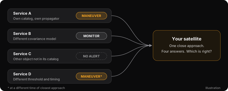
Space traffic management needs one answer per close approach. Today an operator gets several.
Warnings that can’t be reconciled
Each service screens with its own catalog, its own propagator, its own covariance model, its own thresholds and its own probability method. Most of those are not fully open. When their warnings disagree, an operator cannot tell which one is right, because the inputs and algorithms behind them can’t be compared.
Every launch makes it harder
Every object has to be screened against every other. The number of pairs is N(N−1)/2, so it grows with the square of the catalog. Ten times the objects means a hundred times the pairs, and a hundred times the warnings that have to be triaged.
Part six
What Can’t Be Disclosed Still Has To Be Screened
Some satellites are classified. Some maneuvers are commercial secrets until they happen. Neither appears in a public catalog in time to be screened, so other operators plan around trajectories that are about to change. That gap is where incidents come from.
Governments that operate military and intelligence satellites
At least sixteen governments operate reconnaissance or other military satellites. Their orbits, and especially their maneuvers, are not all published. Every one of them shares the same orbits with everyone else.


United States
National Reconnaissance Office satellites; U.S. Space Force


Russia
Bars-M, Persona and Lotos satellites; Russian Space Forces

China
Yaogan satellites; People’s Liberation Army


France
CSO imaging and CERES signals satellites; Space Command, with DGSE among their users


United Kingdom
Tyche imaging satellite; UK Space Command


Germany
SARah radar satellites; Bundeswehr, with the BND among their users

Italy
COSMO-SkyMed radar satellites, military and civil

Spain
PAZ radar satellite, military and civil

Israel
Ofek reconnaissance satellites

Japan
Information Gathering Satellites; Cabinet Satellite Intelligence Center

India
RISAT and EMISAT military satellites; Defence Space Agency

South Korea
425 Project reconnaissance satellites

North Korea
Malligyong reconnaissance satellites

Iran
Noor satellites of the Revolutionary Guard

Türkiye
Göktürk reconnaissance satellites

United Arab Emirates
Falcon Eye reconnaissance satellites
Emblems identify each government for reference only. No affiliation or endorsement is implied. Credits are in the notes.5
Part seven
Why Screening Can’t Wait For Disclosure
No government will publish a classified orbit, and no operator will announce a maneuver to its competitors in advance. Screening has to work without either. That requires computing on data nobody else can read.
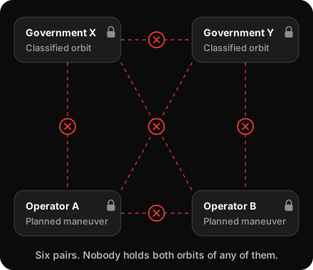
Every close approach needs both orbits
To screen two objects against each other, something has to compare where both will be at the same moment. For most pairs, the public catalog is enough. For a pair that includes a classified satellite or a planned maneuver, one of the two orbits belongs to someone who will not hand it over.
Each government screens its own hidden satellites against what it can see. Each operator screens its own plans against the public catalog. Nobody can screen one government’s hidden satellite against another’s, or a company’s planned burn against a classified orbit, because nobody holds both.
A maneuver opens a blind window
An operator plans a burn hours or days ahead. Screening looks days ahead too, so from the moment the plan exists, everyone else’s prediction for that satellite is wrong. After the burn, radars and telescopes have to notice the change, gather enough new tracking, and solve for the new orbit before any catalog shows it. That takes hours to days more.
For that whole window, every other operator plans around a trajectory that is no longer true, and a close approach inside it is screened against the wrong orbit. Large constellations now maneuver every day, so a window like this is always open somewhere.

Three ways to close the gap, and their limits
Each of the obvious answers asks someone to give up the thing they cannot give up, or to wait until it is too late to matter.
Publication
A classified orbit shows what a satellite can watch and when. A planned maneuver shows strategy to competitors. Neither will be published, and no authority can require every government to publish.
One trusted screener
Every party would have to hand its most sensitive data to the same organization, and every government would have to trust it. One place holding every hidden orbit would also be the most valuable target in space safety.
Waiting for tracking
Sensors see a new orbit only after the burn, and only after hours to days of tracking. By then the close approach has already been screened against the old orbit.
Computing on data nobody else can read
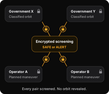
Homomorphic encryption lets a computer do arithmetic on locked numbers. It adds and multiplies them without unlocking them, and the answer comes out locked too.
Screening needs one narrow calculation: how close do these two objects get? One operator locks its trajectory with its own key and sends it. The other works out, on the locked values, how close its own object comes at each moment, and sends the locked answer back. Only the first operator can open it, and it learns only whether the two come too close. Each operator runs it to protect its own satellite. No third party takes part.
Private screening is specified and measured. It is not yet available on the network.
The screening software is open, so both sides can check exactly what was computed, even though neither can see the other’s data.

| Who | What they learn |
|---|---|
| A government with a classified satellite | Whether anything will come too close. Never another party’s orbit or plans. |
| An operator planning a burn | Whether the new trajectory is clear, before the burn. |
| The operator doing the computing | Nothing. It works only on locked values. |
| Everyone else | Nothing. After an alert, the two parties can choose to share more to coordinate. |
Could someone submit invented orbits to find a hidden satellite? Without defenses, yes. In the design, each satellite’s owner answers only questions that match a real satellite’s public track, checks them again afterwards, limits questions per identity and blurs every distance, all on its own node, so running modified software elsewhere changes nothing. The defenses in detail.
Part eight
An Open Baseline With Encrypted Screening
Services can keep competing on sensors, speed and analysis. What they need underneath is one baseline everyone can check, and a way to screen what can’t be shared.
One open catalog
Every source, digitally signed, with its uncertainty attached and the recipe that combined them. Two operators looking at the same event see the same inputs.
Open algorithms
Propagation and conjunction assessment run as open WebAssembly modules. Same inputs, same modules, same answer, on any node.
Encrypted conjunction assessment
Two operators check whether a classified satellite or a planned maneuver comes too close, without exchanging orbits. Specified and measured, not yet available on the network.
Notes
- Anthony “TJ” Koury is the author of Space Data Network and everything built with it: Space Data Standards, OrbPro, SpaceAware, the Space Data Module SDK, FlatSQL, the FlatBuffers WebAssembly toolchain and hd-wallet-wasm, as well as the Evidence-Supported ASO Catalog whitepaper. He created the entire conjunction assessment pipeline after the Iridium–Cosmos collision, from the classified SPADOC and CAVENET systems to Space-Track.org, and the CCSDS standard messages that form the basis of today’s conjunction messaging. He has worked on Space Data Network since 2015. Contact: tj@edgesource.com. The archived Space-Track.org page source names him as its author: open the 23 March 2013 capture and view the source (
view-source:https://web.archive.org/web/20130323001324/https://space-track.org/). - NASA Orbital Debris Program Office, “Satellite Collision Leaves Significant Debris Clouds,” Orbital Debris Quarterly News 13(2), April 2009.
- 10 U.S.C. § 2274, Space situational awareness services and information: provision to non-United States Government entities. Added by Pub. L. 108-136 (2003); amended by Pub. L. 109-364, 110-417, 111-84 and 115-232.
- NASA CARA Analysis Tools.
- Emblems via Wikimedia Commons. Public domain except: Armoiries de la République française by Jérôme Blum, CC BY-SA 2.0 FR; Royal coat of arms of the United Kingdom, Wikimedia Commons contributors, CC BY-SA 3.0; UK Space Operations Centre badge, contains public sector information licensed under the Open Government Licence v3.0; Cabinet Satellite Intelligence Center logo by Ominae, CC BY 4.0.